Best Cross Country Ski Spots
Explore the top trails this season.
By Colin Field


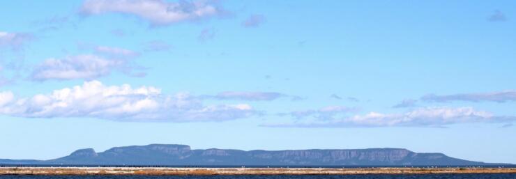
The Sleeping Giant is one of Canada’s most iconic landforms—one that you cannot miss if you drive through Thunder Bay. On any given day in Sleeping Giant Provincial Park, you can identify more than 100 species of birds.
“Hear that?” Parks Canada’s Greg Stroud asks me. Stopped mid-stride, he sang back to an ovenbird that was perched in a tree overhead, “teacha, teacha, teacha.”
We heard quite a few ovenbirds that day, and identified a host of others — Magnolia Warbler, Black-capped Chickadee, Swainson’s Thrush, and Winter Wren. From up on the rock formation itself, the Sleeping Giant feels alive. The forest is dense; there is constant birdsong.
According to Ojibway legend, the Sleeping Giant is “Nanabijou” — The Spirit of Deep Sea Water — turned to stone when the white man was given the location of a nearby silver mine.
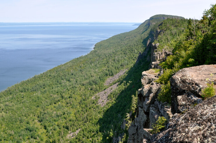
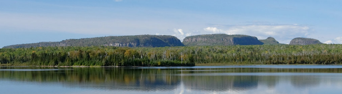
From a distance, the Giant is seemingly at rest. The stone figure sleeps peacefully on his back, arms folded on his chest. He’s mysterious and looming — you can’t escape his presence.
A formation of volcanic rock mesas on the Sibley Peninsula jutting out into Lake Superior, the Giant divides Thunder Bay to the west from Black Bay to the east. The top of the Giant is among the highest points in Ontario and after looking at the Giant for a few days from across Thunder Bay I was finally climbing to the top.
As we hiked along the Top of the Giant Trail, Greg sang along with the birds and identified plants. We saw Thimbleberries, Ostrich Ferns, Largeleaf Asters, Eastern Cedar, and White Pine.
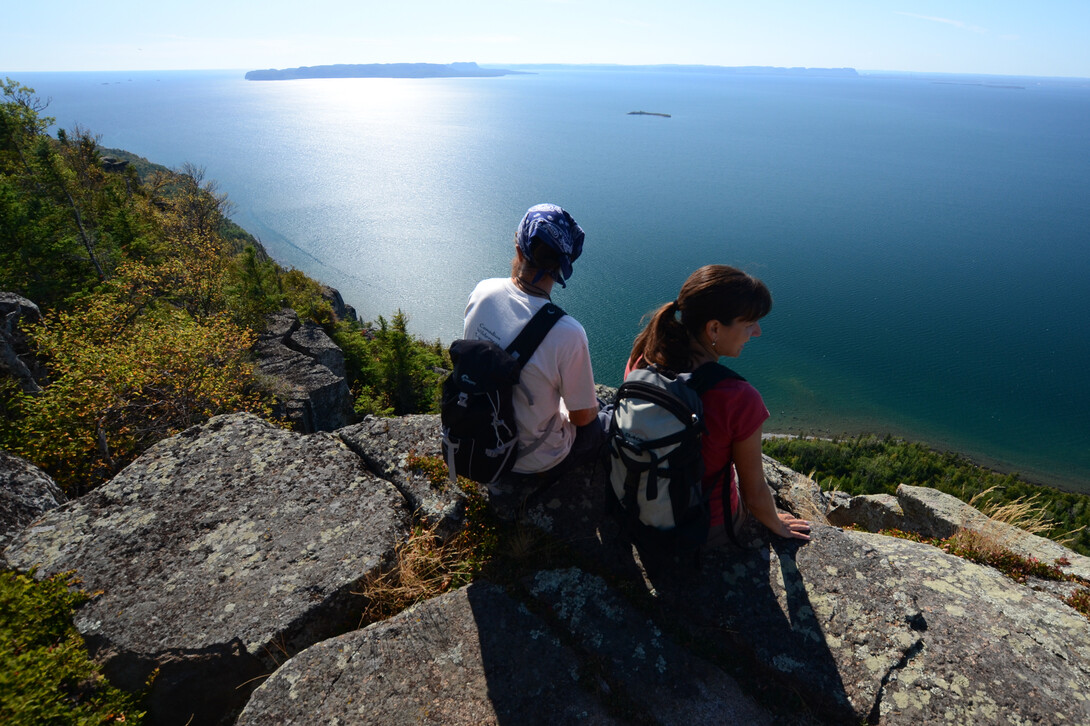
From above Lake Superior, we looked west toward Thunder Bay. The sky and water were a seamless hue of bright blue and the overhanging cliffs dropped straight down into the lake.
“You really have to watch your step,” Greg warned as I climbed out on the cliff to enjoy the view. “Each one could be your last.”
If this were back home in California, I thought, there would be a guardrail. But here in one of Ontario’s most pristine wildernesses there was none, nor any warning signs.
The wilderness was still wild and I ventured out to the edge.
At 290 metres, the dramatic steep cliffs on the west side, at the Giant’s Knees, are among the highest in Ontario. The best view of Lake Superior and the incredible rock formations is from the Lake Superior Lookout at the top of the cliffs.
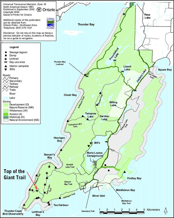
Although often referred to as the Sleeping Giant trail, the hike to the Top of the Giant Lookout and the Lake Superior Lookout actually combines three trails.
The Sleeping Giant hike begins at the south trailhead for Kabeyun Trail with an easy 5.0 km trail that leads just past Tee Harbour. Here you will take the Talus Lake Trail for 1.5 km to the Top of the Giant Trail junction.
The initial 5.0 km section of the trail is an easy hike or a fun mountain bike ride because it is wide, relatively smooth and has rolling hills.
The Top of the Giant Trail is where the real climbing begins. You’ll head straight up the mountain for 2.7 km until you reach the “Top of the Giant,” which sits 229 metres above Lake Superior. There you will find a “top of the giant” sign, a cold creek and a bench for resting.
To get to the Lake Superior lookout it’s another 2.0 km of more gradual climbing. The extra hiking is well worth the trek. Once you reach the end of the trail, you’ll look out over Thunder Bay and Lake Superior from 290 metres above.
Return the same route. The roundtrip distance is 22.4 km.
The Top of the Giant Trail hike is impeccably designed with switchbacks and stairs for the steep sections. This makes for a hike that is physically demanding without being overly technical. The trail winds its way to the top of the Giant and then continues another two kilometres to a scenic lookout atop the knees of the Sleeping Giant.
The hike takes between 6 to 8 hours on average from start to finish. If you want more time at the top, you can ride your mountain bike for the first 5.0 km on the Kabeyun Trail then start hiking.
If you want to break the hike into two days, the camping area at Tee Harbor is excellent. Make sure to reserve a campsite online or call 1-888-ONT-PARK.
First lesson in hiking with a naturalist—they stop a lot to identify plants and birds, so if you aren’t watching your step, you’ll likely run into your nature guide. Sleeping Giant offers a range of naturalist education programs. Check with the visitor center for weekly programming (807-977-2526).
The Top of the Giant Trail in Ontario needs to be moved to the top of your bucket list. Start planning your trip now, visit Thunder Bay and Sleeping Giant Provincial Park.
NOTE: This post is part of Matador’s partnership with Canada, where journalists show how to explore Canada like a local.