
5 Amazing Bike Rides to Discover
Varied terrain, quiet roads, and flowy trails—The Seven is calling.
By Jennifer McCourt


Sometimes you find and see things that are truly extraordinary or different. This is one of them.
Long before writing was developed, people recorded events, ideas, plans, and feelings by marking them on a rock. Rock art is a rather vague term which denotes prehistoric humankind markings on natural surfaces. The rock was their canvas.
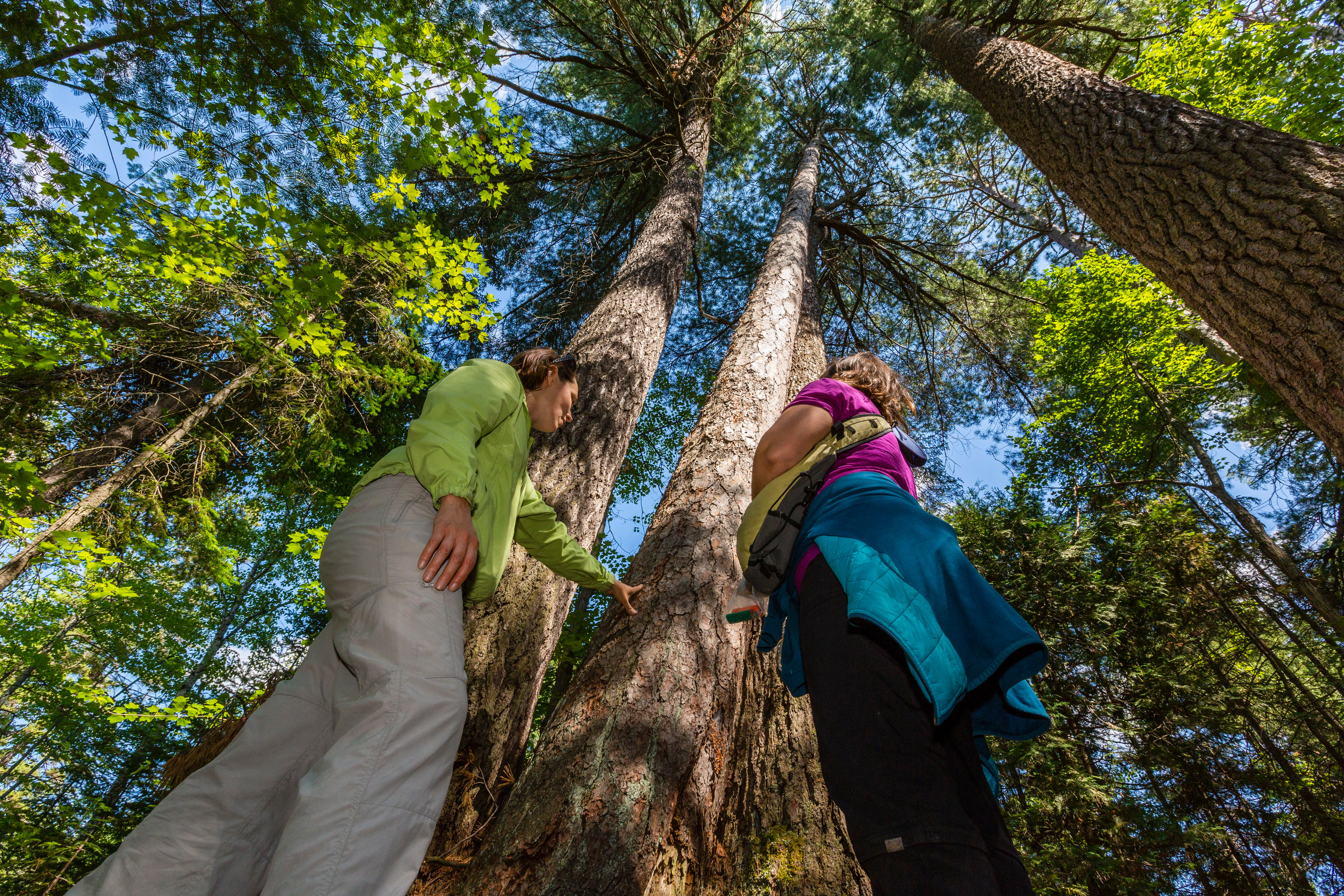
Pictographs are the rock paintings; these are plentiful when compared to petroforms or megaliths, which are the rock piles, like an Inuksuk. Petroglyphs are the rock carvings—there are few of these etchings in Northeastern Ontario and some have been recently re-discovered on a round rock face. This will be a canoe trip with a difference!
The name Temagami comes from Te-mee-ay-gaming, which means deep water, or "deep waters by the shoreline," in the language of the Ojibway first peoples. The rock site itself is a sacred place. It is a place of pilgrimage for local Ojibwa people. Alex Mathias resides at the mouth of the Obabika River, the Lady Evleyn-Smoothwater area. It has been inhabited for 2-3,000 years, and Alex is the custodian of this wilderness area. His first language is the Ojibway dialect, and he is one of a few speakers remaining in the Temagami area—he knows his cultural heritage and is willing to share.
This is a significant destination to understand our early heritage and the use of the elaborate network of waterways called the Nastawgan—the ways or the routes for travel.
Alex was raised in the traditional manner—hunting and trapping, and following the spiritual guides of his forefathers. The Misabi family, to which Alex belongs, are members of the Anishnabai tribe, whose ancestors have treasured and protected this land for many generations. In their time, they have left only a few marks of their presence, in the form of sacred sites such as the petroglyphs. This Obabika area is famous for the late 1980s and 90s old growth forest controversy, when well-intentioned protesters stopped the logging and the area eventually gained protection. In the world of spirituality, the roots, trunk and branches of the tree represent the underworld, earth, and heavens, respectively. “People began to understand the significance of the forest to native peoples,” said Alex.
He remembers going the location when he was a child, but had forgotten about the site. It was rediscovered. “It is for us a type of Mecca where a traditional offering to Mother Earth can be made; it is she who takes care of us,” he says. Alex has embraced aboriginal tourism and offers a number of cultural programs; he is ready to share his rich collection of creation stories with you in a canoe or by the setting of an evening campfire. Alex holds retreats for natives and non-natives through his Misabi Adventure Company, and finds “people are re-energized” by visiting the site. You can see Alex with the pictographs by clicking here.
Ancient petroglyphs do not have "signatures," because they were produced before written words were invented, so they cannot be attributed to a specific person. Petroglyphs can sometimes be linked to a specific group of people who inhabited or passed through the area where the petroglyphs occur.
David Slattery is the owner of Horizon Archaeology Inc. and has been a field archaeologist for more than 25 years.
Dr. Slattery responds to why these petroglyphs are there. “I think there are two reasons. Firstly, as Marshall McLuhan once said, the medium is the message. Actually, he said it many times! Colour may have been a key factor of importance. Technically, petroglyphs give the drawer a more free hand in depictions. Strictly speaking, due to weathering, we cannot be totally sure that petroglyphs were not also painted. Sites often associated with petroglyphs show evidence of multiple re-use suggesting that they were regularly re-visited. Perhaps additional figures were added and other repainted during these later visits.” As to their significance, he says, “some are clearly spiritual in nature, others appear to be 'teaching sites,' while others can be interpreted as territorial markers or even maps of the local area and/or locations of resources.” While theories and interpretations abound, few can be substantiated, and it is not possible to be absolutely sure of either the purpose or cultural function of most sites.
How were the petroglyphs made? Dr. Slattery says that while deer antler was used for the fine finishing work, stone chipping tools we sometimes call awls or borers were used initially. “As for glyphs, there are a few known in Northeastern Ontario. I suspect that it is partly, and only partly, due to the accident of discovery. Most archaeology in Northeastern Ontario has been along waterways where rock paintings (pictographs) are somewhat easier to spot on the rock face. This differs to a great degree from southern Ontario where much larger areas of the interior (ie. areas away from water) have been explored.
"As over 95% of all archaeology in the Province is conducted as part of an Environmental Assessment process for a development project, and given that the government criteria for determining areas of high potential is focussed on the presence/absence of water on a given property, most inland areas, especially in Northeastern Ontario often receive less detailed examination. I have found a few glyphs in the bush, well away from water in Northeastern Ontario. As for the photos you sent me, I had to take a double take, as the style and composition were very familiar from the work I did years ago in the Hisma area of Saudi Arabia. They are not common for animal forms in this part of the Province.” There may be more hidden gems out there.
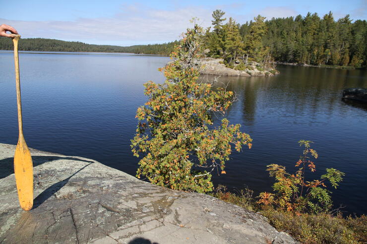
The word Temagami is a marketing word for wilderness. One canoe trip, and you'll see why generations of indigenous peoples, traders, naturalists, photographers, painters, poets, and tourists have lived and been lured by the Temagami area landscape.
Kelly Duquette is the Assistant Park Superintendent, the Temagami cluster of Parks, Ontario Parks. She explains the cultural and natural significance of the Lady Evelyn/Temagami suite of Parks from a public perspective. “The area has a rich cultural history, with archaeological evidence of Aboriginal Indigenous habitation dating back over 6,000 years, and continuing to this day.”
“The wilderness and waterway parks are managed to protect their natural and cultural values, and to provide high quality recreational experiences with minimal facilities. Visitors have the opportunity to experience solitude, challenge and a personal relationship with nature,” she said.
“There are five provincial parks that encompass more than 100,000 hectares in the western part of the Temagami area. Lady Evelyn-Smoothwater, a wilderness class park, lies at the core. The area’s rugged topography includes many high ridges, including Maple Mountain, and Ishpatina ridge—the highest point in Ontario. Four Waterway parks radiate outward from the core; these parks provide a range of remote backcountry travel experiences. The canoe routes within the parks tie in to a larger network of over 2,400 km of rivers, lakes and portages across the Temagami landscape.”
Your destination is the Wakimika triangle, north of Lake Obabika, a trip to celebrate the intricate details and time spent by a shaman or someone, most likely on a vision quest. This is beyond the reach of Twitter’s Periscope app. but an accessible and easy, short enough (three- to four-day) canoe trip found within the “Nastawgan.” Before the advent of roads and railways, the traditional waterways provided the principal routes for travel and communication over much of the shield country.
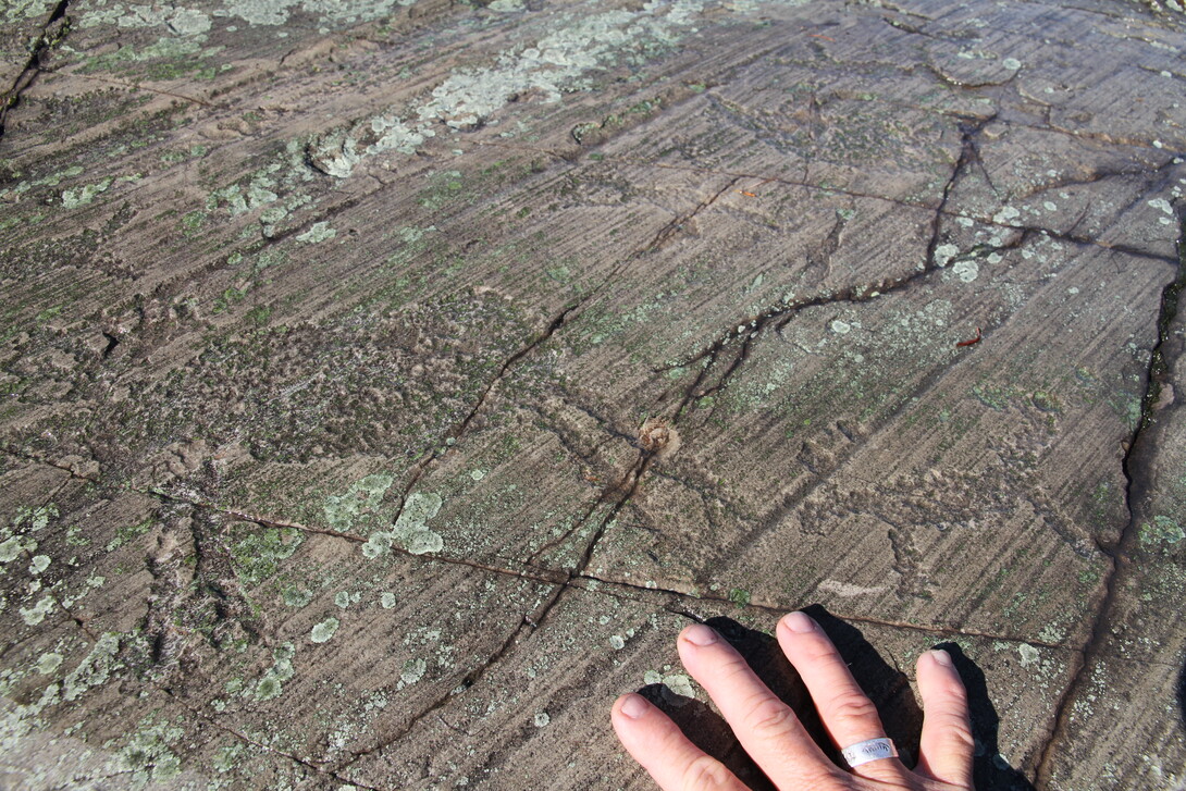
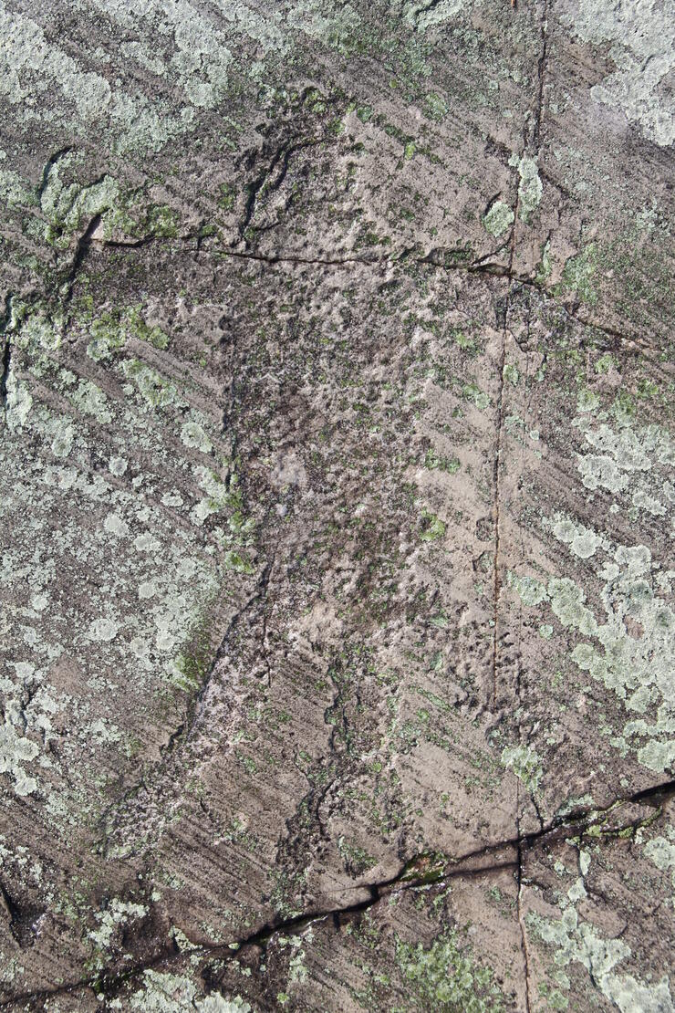
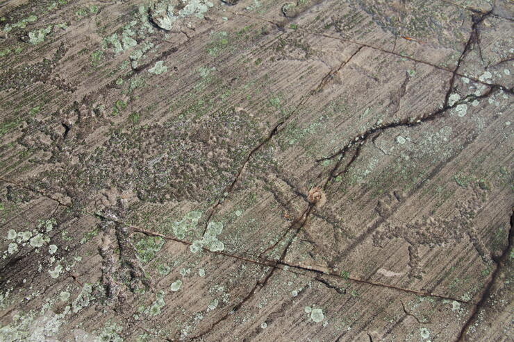
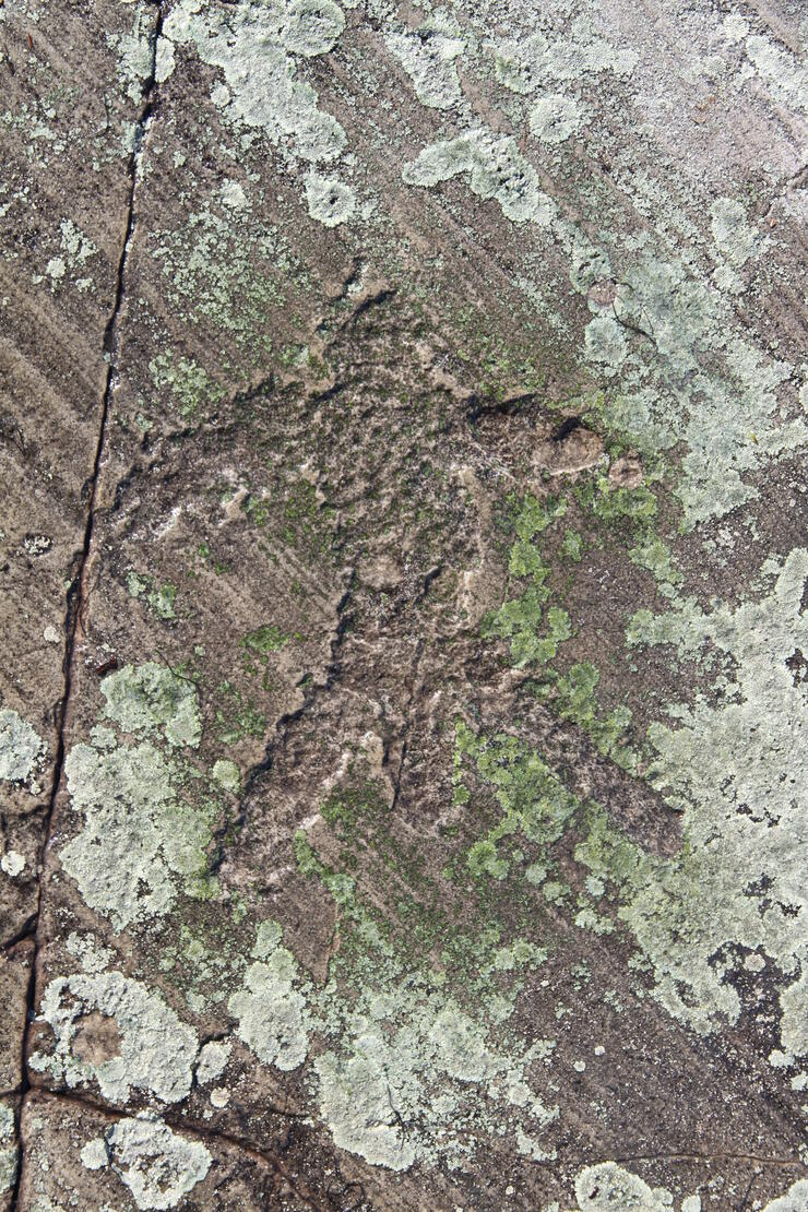
The details of the bull moose and calf are extraordinary; see the rack and legs, and the calf is depicted trailing on the back legs of the adult, as is the case in nature. The dewlap on the neck is right on with detail and placement. There are well-detailed goose and wolf—some of these may be clan signs. There are at least 11 discernible icons, with more covered by the lichen. Depending on the orientation, one is a turtle; another seems to be a well-endowed man. All are open for interpretation. The different petroglyphs do not have the same direction of the glacial striations running NE to SW. Now that you know, see the spatial details. It is a sacred site—be sensitive, leave an offering.
There are three small islands on eastern shore Wakimika Lake and the site is on the NNW corner of the largest, find the bulbous smooth rock; you will a small island off to the NNE. WGS 84 N47° 09.358' W80° 20.128'; UTM 17 T E550374 N5222710. Visit www.steerto.com for the Google map link to this location and access points.
These rock carvings are unique and different alright, a one of a kind. What were the ancients trying to tell us? Their voices are silent, and it is left to us to interpret their message and mythology. This is canoe trip worth taking and a place worth recognizing with respect; a “must see and do” in the back waters.