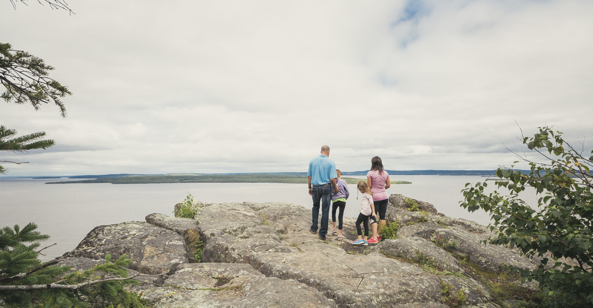

Northern Lights in Northeastern Ontario
5 great spots in The Seven to find the Aurora Borealis.
By Northeastern Ontario Tourism


It is not often that you can go for a drive and experience the past as vividly as you can on Highway 11 – what was once just a back road into Northeastern Ontario now forms the main route into and out of our beautiful region.
Visitors from the south have been having BIG adventures in Northeastern Ontario for a long time now, but it was once just a gravel and dirt road known as the Ferguson Highway that blazed a path into the pristine wilderness we know today.
When you’re heading north into Northeastern Ontario you can be thankful for the four lanes that make up much of Highway 11 right up from Toronto. The completion of Highway 11 to North Bay is recent but when you continue northwards from the city known as the “Gateway to the North” things are a little different, and they always have been. The highway remains a work in progress, the story continues. What was it like “back in the day?”
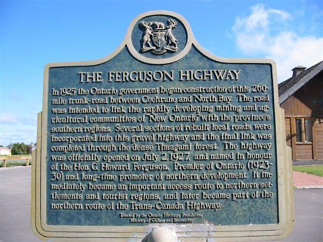
At the Latchford information centre, just north of Temagami, there is a commemorative plaque acknowledging the grand opening of Highway 11 North. "In 1925 the Ontario government began construction of this 260-mile trunk road between Cochrane and North Bay. The road was intended to link the rapidly developing mining and agricultural communities of ‘New Ontario’ with the province's southern regions. Several sections of rebuilt local roads were incorporated into this gravel highway and the final link was completed through the dense Timagami [sic] forest. The highway was officially opened on July 2, 1927, and named in honour of the Hon. G. Howard Ferguson, Premier of Ontario (1923-30) and long-time promoter of northern development. It immediately became an important access route to northern settlements and tourist regions."
Although it was named for the man who campaigned on the promise of building the road, the Ferguson Highway was originally planned as a trunk road to connect the communities of southern Ontario to North Bay. In 1919, Premier of Ontario, Ernest Charles Drury, created the Department of Public Highways and the new department's jurisdiction did not extend north of the Severn River. It was instead maintained by the Department of Northern Development, similar to the present Ministry of Northern Development and Mines. Drury was Ferguson’s predecessor.
But in the beginning, the Ferguson Highway was a quick and cheap political promise to the north. It was a response to the evolution of cars and trucks and an alternative to the railroads. What it really meant was that the road wandered from point to point, using the highest ground possible, avoiding the myriad of small lakes and wetlands of the Canadian Shield, making it a modern day favourite with motorcycle riders and road trippers, for its “twisties” value.
Although the Ferguson Highway linked Cochrane and Timmins to North Bay, in reality the road couldn’t be used for much of the year. Every spring the freeze and thaw regime swallowed up whole sections and the rains washed away portions of the gravel roadbed and wooden bridges. Stonemasons were required for permanent bridges and these permanent structures were costly to the Crown. It wasn’t until the 1950s that all of Highway 11 was paved with some uniformity. With the advent of hard rock blasting and heavy road construction machinery, the road could start to be developed as a more hardy, permanent path into Northeastern Ontario.
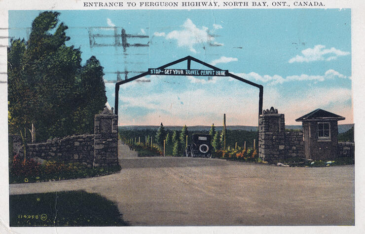
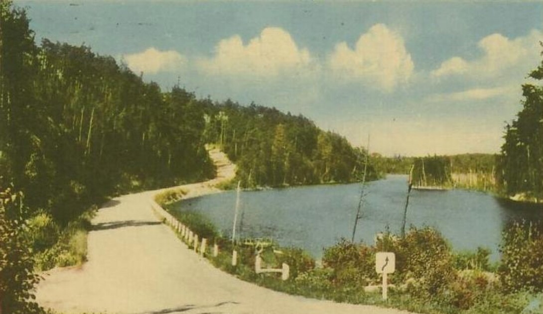
The formative years of this development were so precarious that the young highway required visitors to sign in, register their vehicles, and receive a permit to travel northwards. A toll booth was located just north of Thibeault Hill in North Bay, near Cooks Mill Rd., just past the psychiatric hospital, and was open for the summer season only. You took your chances driving northwards. The birth of the Dionne Quintuplets on May 28, 1934, and the increasing popularity of vacations spawned the early beginnings of Northeastern Ontario tourism using Highway 11 North. It was the very beginnings of hunting and fishing and family vacations. Historic post cards along the way tell the story of getting there – it was an adventure in itself.
You can see “what was” of the Ferguson Highway a little north of Marten River.
Motorized or non-motorized it is a great jaunt for a scenic drive, cross-country ski, walk, snowmobile (the old highway is now the snowmobile OFSC “A” Trail), ATV, mountain bike ride or snowshoe excursion. If you are a back roads motorcyclist always on the lookout for “a little gravel” to practise your skills, this is a great adventure.
It’s 58 km from North Bay (Airport Hill/Hwy. 11 Junction) to the Marten River Provincial Park entrance and it is another 11.9 km from there to the Tonomo Lake Road, turn left or west. At this junction the stream water flows southwards from Pan Lake on Highway 11 to Red Canoe Lake (Olive Lake). The remnants of the Ferguson Highway are found on the 1:50 00 topographic map, ‘Ingall Lake’ – L/13.’
Set your odometer or GPS unit. The pipeline compressor station is 2 km northwards and as winter arrives you could park here. The old highway is now a seasonal access to camps and cottages, the pipeline, a power corridor, and part of a designated snowmobile trail.
It feels like an old road with lots of ups and downs, the road meandering around small wetlands, near lake shorelines, and over too many hill crests with blind spots.
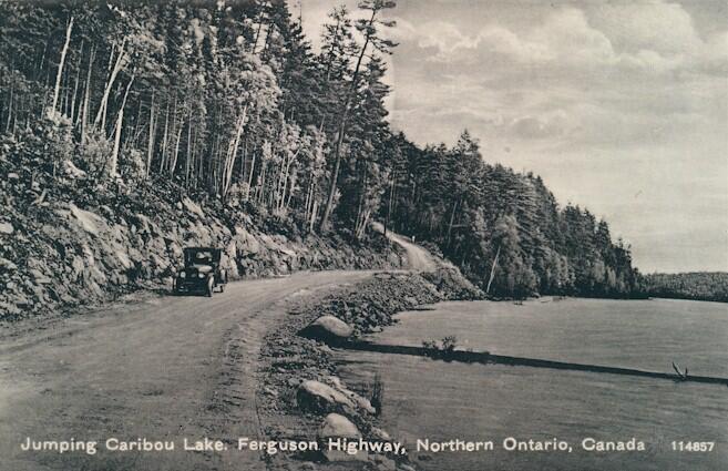
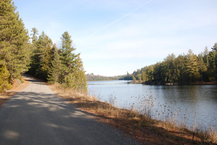
Geo-referencing a historic photo means that you try and stand at the same location where the original photographer stood. At 5.1 km you will be at the location of the historic tourist post card of the Ferguson Highway. You can’t stand quite exactly where the photographer positioned a tripod as there is a row of mature cedar trees lining the road. The original vegetation was cleared for the new highway. There is a gap and there is no mistaking the island in the picture on the east side of the post card. This scenic highway spot was captured some 75 years ago on at the south west arm of Jumping Caribou Lake (N46° 52’ 19.7” W79° 48’ 35.0”).
The road in the photo then winds its way up a hill and down to 5.7 km, to what was once a popular roadside rest stop and bridge, the water leaving Jumping Caribou Lake, flowing southwest to Hangstone Lake.
It is good to know your pace because here you will see the remains of two, timber cofferdams, utilized to raise water levels for log chutes. For Dam Number One, walk 40 m eastwards or upstream, look for the trail on the left or north, walk to the water and view the horizontal timbers (N46° 52’ 39.2” W79° 48’ 32.2”). For Dam Number Two, continue on and walk another 100 m on the east-west access road, cross under the power line, walk approximately another 100 m to a gate. Here, take the trail at the ‘P’ portage sign down to the rapids (N46° 52’ 37.8” W79° 48’ 16.3”). This is a great location to launch your canoe or kayak for a paddle on Jumping Caribou Lake.
At 7.5 km, Tonomo Lake Road (south section) transitions down a steep hill to what becomes Wilson Lake Road (north section), where there is a view of Dewy Lake to the west. At 9.0 there is a spring water source; 11.3 Brophy Creek with a view to the east of Waha Lake. Take a look at the underpinnings of the original bridge. This is a great canoe access to one the most picturesque lakes in the area, Wasaksina.
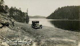
At 13.9 you see Christy Lake to the east; at 15 there is an expansive view of Wilson Lake to the west; 16.8, North Milne Lake to the east and at 18.2 you join the newer Highway 11 north. Two km north take the Lowell Lake Road. It remains the old highway and as soon as you come in contact with the water it is the next historic post card view.
When you return southwards, the present day highway is 17.7 km in length, paralleling the Ferguson highway to the west, which is 18.2 in length. That’s about one half of a kilometre difference, but it was all about speed and time and the ever-increasing size of car and truck motors. The highway of today now goes through more than 30 rock cuts of various sizes within the shorter distance; there are no hills with crests or curves to worry about.
On the original Ferguson Highway the speed limit might have been 40 km/hour in good conditions. What now takes you approximately 12 minutes on Highway 11 would have taken you more than 30 minutes taking care and caution. Like the post card, this old road that once was, is a souvenir from the tourism heritage of Northeastern Ontario.